
2006 routes to the South Summit of Antisana
GENERAL INFORMATION FOR ALL ROUTES
2005 and 2006 were intense years in terms of opening and repeating routes on the southern peak of Antisana, because, on October 2005, Nicolás Miranda and Rodrigo Acosta got a fairly technical variant on the northeastern face; Later, the students and instructors of the ASEGUIM courses for aspiring guides opened some more (Ecuadorian Mountain Guides Association), amidst intense stories and great difficulties.
Base Camp
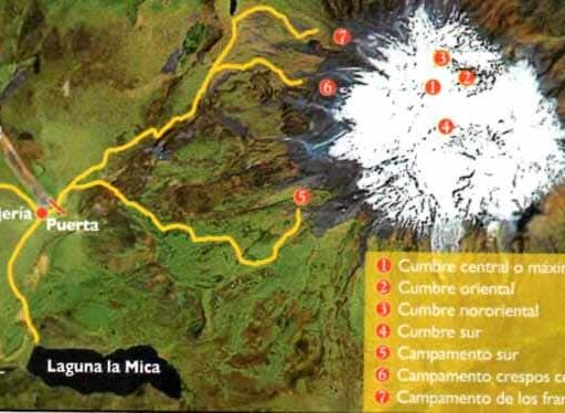
The base camp (CB) was the same for the opening of routes 2, 3, 4, 5 and 6. It was located below the western face of the southern peak, at 4,460 m., 300 meters further south of the southern camp.
Descent
All the ropes made the descent that is explained below: from the summit, advance a few meters north to the beginning of the spur; There, take a small channel of five meters until reaching the site where the first of the three rappels is installed, these end at the glacier. Continue along the glacier avoiding the cracks, first to the west and then to the north, until joining the normal route of the central summit that begins at the southern crespos.
VIA 1, Nuevo Amanecer, 2005
N. Miranda, R. Acosta.
- Date: November 27, 2005, Antisana, South Summit, 5706 m
- Route: “Nuevo amanecer”, northwest face. Variant of the S route, opened by M. Reinoso, J. Anhalzer and H. Torres, on 1982
- Grade: 600m (9 lengths of rope), VI (MD) 100o, 5 hours.
- Necessary material: 3 ropes of 60 meters, 6 ribbons, 4 snow stakes, 6 screws
- Base camp: South camp
Cross the moraine and then the glacier towards the north-western wall. Climb a snow shovel that connects to the gutter that leads to the top seracs; a little before reaching the seracs you have to climb a belly of 10 meters and 100 degrees. Evade the seracs on the right side and exit to a 65 o snow shovel that joins the ridge that ends at the top.
VIA 2, Truenos y centellas, 2005
F. Jácome, G. Navarrete, l. Espinosa.
- Date: October 26, 2005, Antisana, South Summit, 5706 m
- Route: “Truenos y centellas”, western face.
- Grade: 650 meters of unevenness, 420 meters of climbing, 7 lengths, V (TD), 90 o, IV, 9 hours.
- Necessary material: 2 ropes of 60 meters, 6 ribbons, 2 snow stakes, 5 ice screws, 3 assorted rock nails, 1/2 set of nuts (medium and small), 4 camalots (0,5 — 0,75 — I – 2 )
From the BC, follow the Antisana river bed and then the ridge on the left side of the river to the glacier. Then, climb between the southern edge of the glacier and the northwestern spur of the South Peak, until you find a very thick strip of volcanic red rock. The entrance to the route is between the strip and the spur wall.
VIA 3, Espolón del chiquitín, 2005
R. Sandoval, R. Solari, B. Shlauri, F. Iza.
- Date: October 26, 2005, Antisana, South Summit, 5,706 m
- Route: “Espolón del chiquitín”, southwestern spur.
- Grade: 700 meters (5 lengths), IV (D+), 90o, V, 8 hours.
- Necessary material: Two 60 meter ropes, 5 long ribbons, 1 snow stake, 5 ice screws, 3 assorted rock nails, 1 set of nuts
Follow the approach of route 2 until you reach the glacier and then climb the edge of it to the beginning of the spur. Start at the volcanic rock plinth; continue to a ledge and turn right to climb on the ridge of the spur. Continue to the base of the mixed corridor (65 o -75 o); and then, climbing two pitches on ice, of medium difficulty, ending with 8 meters of 90 o. Exit to the snow ridge (70 o) that leads to the southern peak summit.
VIA 4, Cosa de niños chismosos, 2006
R. Cáceres, N, Miranda, S. Carrasco, I. Espinosa.
- Date: April 20, 2006, Antisana, South Summit, 5,706 m
- Route: “Cosa de niños chismosos”, south spur.
- Grade: 700 meters, VI (ED inf.), 6a+, A2, 900, 10 hours.
- Necessary material: Two ropes of 60 meters, 8 ribbons, 4 stakes, 2 TCU, 5 screws, 4 assorted rock nails, 1 set of nuts, 3 camalots (0,75 – I -2 )
From the BC, advance to the obvious ridge on the right, which leads to the base of the south spur. About one hour. Start on the southern ridge that descends from the southern spur; In this section it is possible to make a rapid advance with a short rope until reaching a first rock wall, at 4,800 m., which requires a meeting point and rope. Then, continue along the ridge until you find a 10-meter rock chimney (Vl-) that connects to a very exposed path, heading north, on bad rock. This ends at the beginning of a great fifty meter chimney in bad rock (6a +) and doubtful insurance; This is the hardest section of the route, due to the fall exposure and the threatening barrier of seracs over the spur. Upon overcoming this section, you reach mixed terrain; climb a pitch until reaching an extra-plumb chimney that requires an artificial A2 step; climb a further length of M4 to get off the spur. Finally, make an upward crossing to the right, towards the south-eastern face, to reach the final ramp of 300 meters that leads to the somital ridge.
VIA 5, El que piensa pierde, 2006
R. Garrido, M. Moine, J. García, P. García, X. Carrera, A. Lazzati
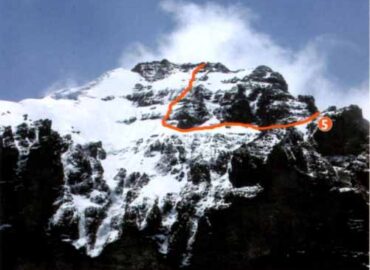
- Date: April 20, 2006, Antisana, South Summit, 5,706 m
- Route: “El que piensa pierde”, south face.
- Grade: 650 meters (9 lengths), V (D), 65o, 7 to 8 hours.
- Necessary material: Two 60 meters ropes, 6 ribbons, 5 stakes, 5 screws, 2 nuts, 2 friends
From the south base camp, go around South Peak heading east; cross the first ridge and climb the second to the glacier base. Approximate time to the base of the glacier 4 hours. From the glacier base, ascend 200 meters along the ridge, on the eastern side, until you find the first ice channel that get you to the shoulder, on the ridge. Then, make a crossing of 150 meters to the left (west), at the same elevation, until you overcome the rock band and come out to the snow or ice shovel. The 9 pitches of 65o start there on mixed terrain, with very delicate rock and snow points of security. Finally you reach the ridge through which you must make a journey to the southern summit.
VIA 6, Variante de la Vía de la plegaria, 2005
J. F. Dueñas, F. Varela, F. Salcedo, E. Oña, H. Pineda, A. Lazzati
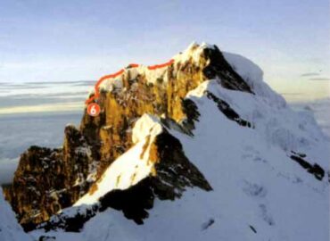
- Date: October 26, 2005, Antisana, South Summit, 5,706 m
- Route: Variant of the Vía de la plegaria, opened by Gabriel Llano, Oswaldo Freire and Oswaldo Alcocer, in 1993, south face.
- Grade: 650 meters (8 lenghts), MD+, V+, 7 to 8 hours.
- Necessary material: 2 ropes of 60 meters, 7 long ribbons, 3 snow stakes, 5 screws, 3 assorted pegs, 1 set of nuts, small friends
From the south base camp, go around the South Peak heading east; cross the first ridge and climb the second to the glacier base. Approximate time to the base of the glacier 4 hours. From the glacier base, climb 200 meters along the ridge, on the eastern side, until you find the first ice channel that lead you to the shoulder, on the ridge. Continue with a journey towards the caldera, heading east. Finally, climb the obvious gutter to the final ridge that leads to the summit.
SOURCE: Revista Montaña No. 23, July 2006
Author: Ignacio Espinoza