
Cerro Puntas Map
(Click on the GPS points to see the photos; use two fingers to move the map)
Get Directions
Routes
routes
| Route | Difficulty | Time |
|---|---|---|
| Normal Route (Hda. Teresita) | Easy | |
| Hacienda – Highest Summit | Easy | 4 – 5h |
| Highest Summit – Hacienda | Easy | 2 – 3h |
| Alternative Route “The waterway” | Easy | |
| Hacienda – Highest Summit – Hacienda | Easy | 6 – 7h |
- Recommendations
Recommendations
- You can ascend to Cerro Puntas following any of these two routes: Hacienda Teresita, owned by the Ríos Family; or The waterway.
- The most frequently used route is through the "Hacienda Teresita". The entrance road starts a little beyond Checa, following towards El Quinche town. This road is mostly stone cobbled and climbs very steeply until it reaches the hacienda gate. The door is always closed, just at the entrance is the hacienda's office, where you must ask for permission to enter. They are currently charging US. 2.00 per person and you can go by with the vehicle. Although there is usually someone who attends, with a little bad luck it could be that you can't pass.
- From the hacienda you can still climb a little more by a 4x4 road to the milking pens where they have built a new house. This is the best place to park the vehicle. In summer times, with an excellent 4x4 and a good pilot it's possible to get very close to the rocks, although it's difficult and is not really recommended.
- The hike starts directly up. This dirt road zigzags through pastures and paramo until you reach the Puntas rocks. To save time, you usually take the shortcuts that cross the pastures, in case it's necessary to open a wire fence, it's very important to leave it closed to prevent livestock from escaping.
- You can choose to follow the "car" road without deviating; it will eventually lead you to the foot of the Cerro Puntas northwestern rocks.
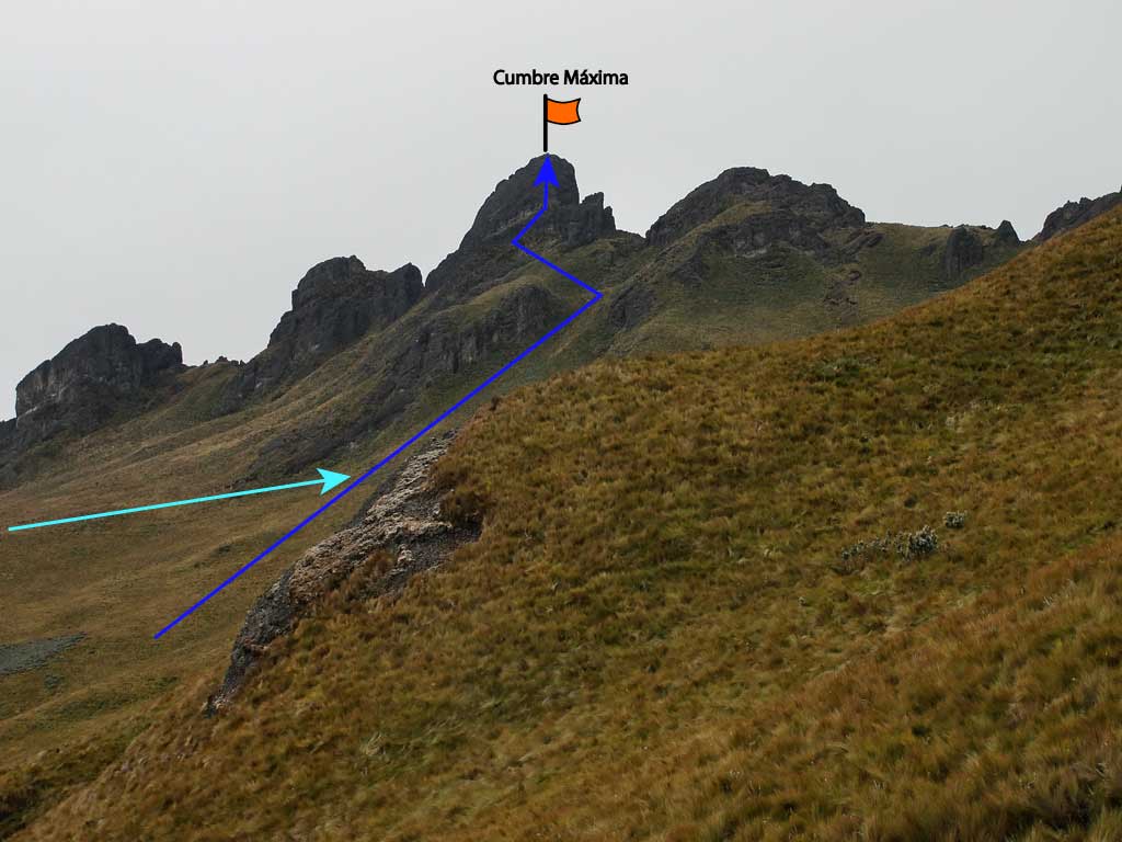
- This ancient volcano has a horseshoe shape composed by two chains. The main summit is in the north-western chain which is much easier to reach. The southeastern chain has also many rocky peaks, very rarely climbed because of the difficult approach. There is little information available about these southeastern peaks and it's possible that some of them are still virgin.
- Cerro Puntas has approximately between 40 to 50 rocky peaks with different height and difficulty , it offers many hiking possibilities for the more adventurous, it could also be very attractive for climbing since very few routes have been opened and most of the people feel happy following just the known route to the highest peak.
- The highest summit requires a 20 meters climb with a fourth degree through the southwestern wall, although it can be difficult to find intermediate security points, the better will be to climb without stopping to the summit and fix a rope for the less experienced.
- it's advised to descend by rappelling from the summit.
- Cerro Puntas is at the Ecuadorian eastern mountain range, receives a lot of humidity in the winter season, which is why it's common to find it cloudy and in the worst case many have had to endure a good hail. it's very important to get away from these peaks when a thunderstorm is suspected.
- Another possible route is through the waterway , it's an alternative route that starts at another ridge.
- The 4x4 vehicles road climbs directly to Cerro El Tablon, and ends at the door of another hacienda.
- Previously, before arriving to this last hacienda, there is another metal gate, people usually opens it early in the morning and closes it at night. Vehicle or people traffic is allowed during the day.
- The hacienda door is usually closed ; If you go from monday to friday, it may be possible that you can't get through and because of the narrowness of the road there is no appropriate place to park the vehicle.
- On weekends it's easier to find an hacienda worker that allows you to pass. It may be that they charge you something.
- The vehicle is parked a little above the hacienda door, and the hike starts directly towards the "El Tablón" following a path through the paddocks. This trail can take you to the summit of "El Tablón", or you can take another path that goes to the right and reaches the waterway.
- The waterway continues along the northern slope of the ravine that separates the Tablon from Cerro Puntas , goes in an easterly direction until it reaches the humid valley that separates both mountains. From there it's necessary to cross this valley, where you will have to cross a stream and look for the passage through a rather dense paramo. Afterwards, you could take a visible path that leads to the foot of the Cerro Puntas rocks. There are two peaks before reaching the main peak, these peaks are tilted by the northwestern face.
- This trail ends at the foot of the same rock wall of the Cerro Puntas main summit.
- The southeastern chain has the least climbed and most mysterious peaks of Cerro Puntas. There are very few people who have ventured into these places and there is little or no information about these peaks.
- Surely the best way to enter this chain is to follow the waterway and then try to negotiate the passage through the valley in the direction of these rocky peaks.
- it's also possible to get there by the normal route of the Hacienda Teresita, arriving at the foot of the main summit and bypassing by the northwestern face following the north direction, and later looking for a feasible pass which allows to connect with the Southeast chain.
