
Chimborazo Map
(Click on the GPS points to see the photos; use two fingers to move the map)
Get Directions
Routes
routes
| Ruta | Dificultad | Tiempo |
|---|---|---|
| Normal Route | A little difficult (PD) | 11 - 16h |
| Glaciar Thielmann Route | Fairly difficult (AD) | |
| Whymper Route | Fairly difficult (AD) | |
| Directísima Route | Fairly difficult (AD) | |
| Nicolás Martínez Normal Route | Fairly difficult (AD) | |
| Nicolás Martínez Arista del Sol Route | Difficult (D) |
- Recommendations
Recommendations
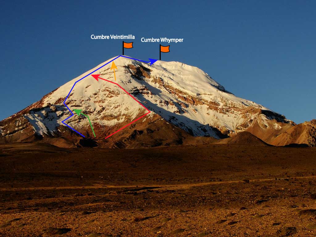
- The normal route to the Whymper (or Highest) summit starts from the refuge in the direction of the rocky ridge on the northwest (El Castillo); later it goes to the Veintimilla summit and after it to the Whymper. This route does not present major technical difficulties. All other routes to the Whymper summit and the other summits of Chimborazo can present difficulties and require good physical and technical training, as well as the appropriate equipment.
- The Chimborazo has two refuges: the Carrel refuge at 4855m and the Whymper refuge at 5035m , both on the western side of the mountain. These refuges have a rate of approximately US 15 per person to sleep; US 25 includes the full board with dinner and breakfast. The two are small shelters and sometimes you will not be able to find a space. There are mattresses; but it is essential to bring a sleeping bag to sleep. The guard can sell you drinks and basic food, such as soda, coffee, tea and snacks. The kitchen is not open to visitors.
- To date (July 2018) the Whymper Refuge is not providing services. This refuge is being opened seasonally depending on the number of visitors.
- Camping is allowed free of charge next to the Carrel Refuge with the choice of accessing the restrooms. Camping is not allowed above this refuge, including next to the Whymper.
- Do not try the Chimborazo without having done a good acclimatization. The Chimborazo in the most demanding mountain in Ecuador, if you aspire to reach the summit you must be very well acclimatized and physically trained.
- People usually goes up to the summit at night between 22:00 and 23:00. This is customary due to the equatorial sun which can strongly hit the slopes loosening the snow and the ice bridges over the crevaces.
- The first section follows a trail in a northwesterly direction until reaching the base of the rocky formation known as “El Castillo”, you go through a sand and snow corridor until getting to the glacial ridge that leads directly to the Veintimilla Summit. Depending on the amount of snow or ice, it may be necessary to use crampons from the beginning of the corridor.
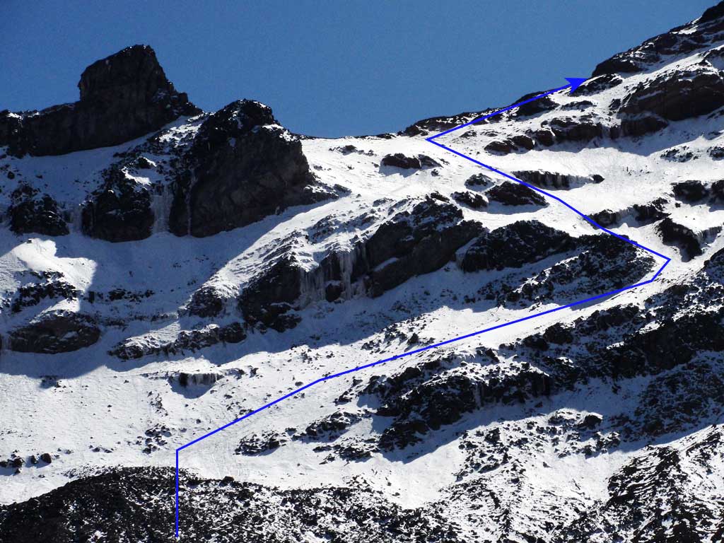
- The “El Castillo” climb can be considered the most critical section, where the greatest technical difficulties will be encountered, especially the constant danger of falling rocks.
- An alternative route called “Huarhuallac” has been used the last years, starting the trek at the Carrel refuge to the north, with the intention of tilting the rocky edge of the Castillo on its upper section and reach the same glacier to the Veintimilla. This route has practically replaced the old “corridor” route, but requires an additional hour to this already long climb, which means leaving between 22:00 and facing a very hard day to the summit.
- There is currently an area for camping approximately 5300 meters high and very close to the “Castillo”. Its use is not recommended when the Chimborazo is heavily loaded with loose snow.
- After leaving the “Castillo”, take directly the glacier towards the Veintimilla summit, it is basically a very long hike, demanding, without major dangers, although it may be necessary to cross some cracks. This section has an average inclination of about 35 degrees.
- In summer the wind can blow very strongly. Chimborazo temperatures can be very low, so it is necessary to be prepared for this adverse weather.
- Normally you will reach the Veintimilla summit after about seven hours and with the first sun rays. There are many who end up walking on the four, very similar to the pack animals at lower elevations, defeated by the altitude and the weight of his or her backpack. But don’t suffer, you will be almost 1250 meters over the refuge, and Edward Whymper himself told that he ended up walking in this very peculiar way.
- Prepare your body and soul with some yoga therapies, they will come very handy when you reach the Veintimilla summit and you find out that you still need an additional hour until the Whymper. The guides are usually very gentle and will always estimate about 30 minutes to the Whymper; so do not worry.
- This glacier at 6000 meters is famous for its loose snow, although it’s not a law, very often you will sink to the waist.
- Without a doubt, you will never forget this wonderful 6268 meters summit, the highest mountain in Ecuador , the most distant place from the center of the Earth and closest point to the Sun.
- Other routes to the Chimborazo have been opened sporadically and are only recommended for experienced mountaineers.
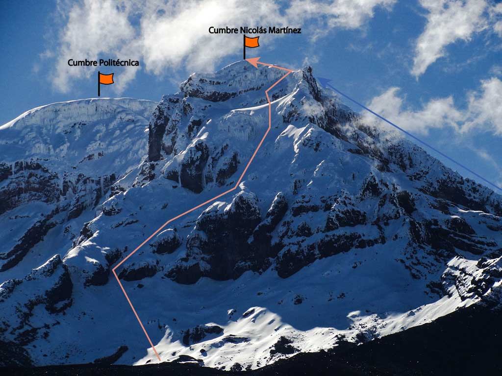
- The eastern Chimborazo face, at the foot of the Nicolás Martínez summit, presents perhaps the most beautiful Chimborazo landscapes. The only problem is that it is very rarely visited, so the approach can be difficult, unlike the desert sand on the western side, the eastern side has a very dense paramo high up on the mountain. The trails opened on this paramo are quickly closed due to the very limited visitors traffic. So if you are an adventurous one, prepare to deal with a hard hike on the pure pajonal to the Nicolás Martínez foot, and don’t be afraid of those nice rocks, they are perfect for “professional” mixed rock and ice climbers like you.
