
Cotopaxi Map
(Click on the GPS points to see the photos; use two fingers to move the map)
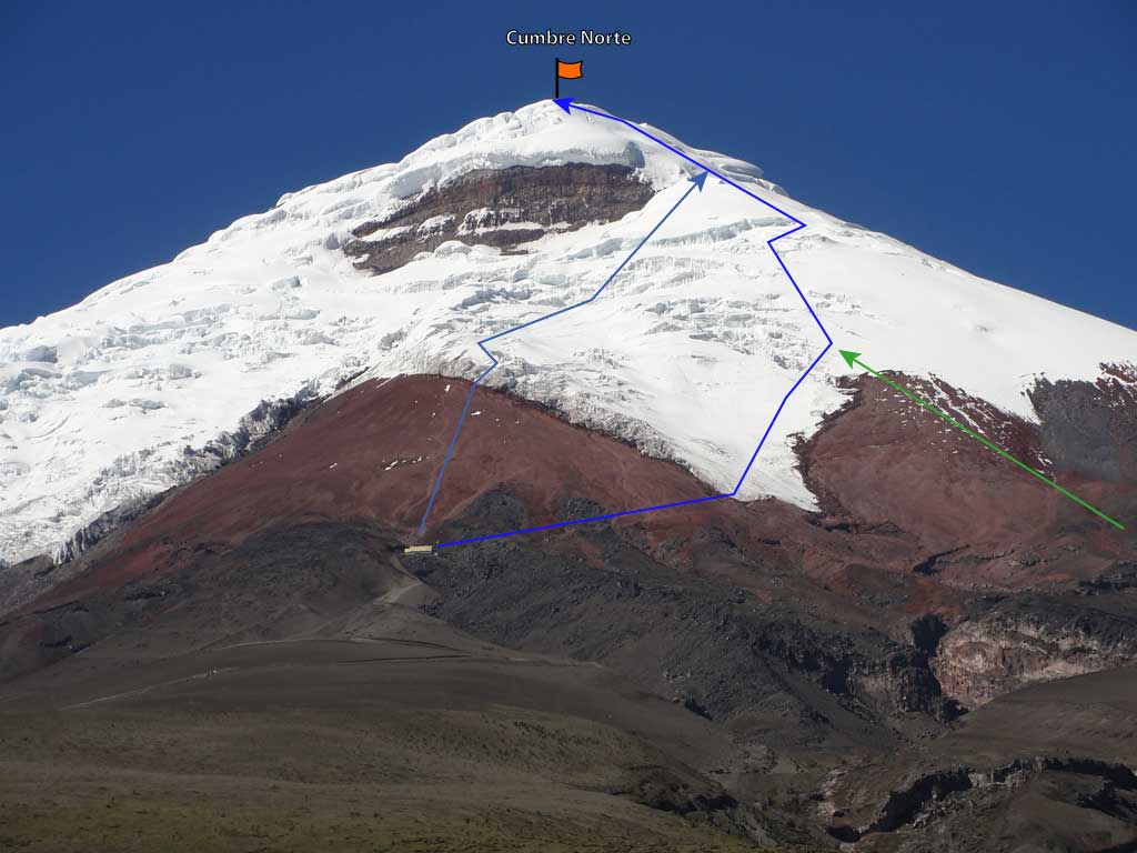
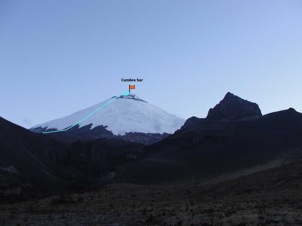
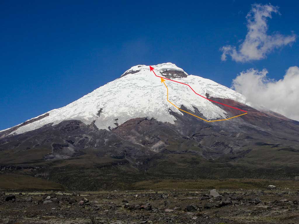
Routes
routes
| Route | Difficulty | Time |
|---|---|---|
| Normal Route (Round Trip) | A little difficult (PD) | 7 - 11h |
| Normal Route (Alternative) | A little difficult (PD) | 7 - 11h |
| South Route | A little difficult (PD) | 8 - 13h |
| Perez de Tudela Route | A little difficult (PD) | 8 - 13h |
| “Sin Querer Queriendo” Route | Fairly difficult (AD) |
- Recommendations
Recommendations
- Both the northern route and the southern route present similar difficulties in the ascent; although the southern route requires a longer approach and a hi camp near 4700 meters. The southern route is much less frequented and therefore the path to the summit is less marked and requires greater technical solvency in the mountain, likewise, it's advisable to use flags to guide you on the return route.
- The José Ribas Refuge on the north side was remodeled and reopened on August 4, 2016; has everything you need for a pleasant stay before climbing to the summit. This refuge has a rate of US 30 per person with dinner and breakfast included; You can request breakfast when you arrive from the top and not before leaving, which is very convenient. US 20.00 without dinner or breakfast. The kitchen is not open to guests. it's highly recommended to make a reservation at least 15 days in advance.
- it's forbidden to camp outside the Jose Ribas Refuge.
- don't try Cotopaxi without having done a good acclimatization.
- People usually go to the summit between 11:00pm and 2:00am. it's customary to climb at night due to the equatorial sun which can strongly hit the slopes loosening the snow and the bridges over the crevasses.
- If you arrive sweating and half tired at the beginning of the glacier (5240m at the normal alternative route), don't be demoralized, many have reached the summit after that setback.
- There are some crevasses in any of the two routes, some of them look like cathedrals. Do the favor and don't slip on one of them...
- The normal route is usually very congested at certain times of the year, especially the summer months. If you don't leave early, get ready to follow the Indian line of innumerable "cordadas" climbing at turtles speed, you may pass them with much difficulty or endure the "tun tun" step to where your patience resist it.
- The summer months (especially July and August) can be windy and greatly hinder the climb, with the advantage that the descent will have tail wind and you will almost fly like a feather.
- The climb is hard, especially the last hour and a half. Both routes have their highest inclination of about 40 degrees near the crater border. This section runs on the right side of the Yanasacha wall on the normal route.
- Normally you will reach the summit after six hours of walking and with the first sun rays. If you are lucky with the weather, the crater view on a clear day is something truly unique and masterful, sure you will feel very tired but realized and happy. Another show is the 360 degree view from the summit strategically located in the middle of the Ecuadorian Andes.
- Sometimes the volcano has more activity, then it's possible to see columns of steam and hear the sounds of badly cured flu, also the smell of sulfur can be very evident.
- The return to the refuge takes between two and three hours; you must be very careful to not deviate because there are still old marked routes that converge on this same main path to the summit.
- Undoubtedly, the ascent to Cotopaxi will always be a very rewarding experience.
- The south face has also a refuge "Cara Sur" Refuge at 3900 meters. The refuge is well equipped and if you book early you can hire mules to take the load to the upper camp. Very convenient for acclimatization is to spend the night at this refuge and the next day climb up to the hi camp, lengthening the Cotopaxi climbing one day.
- Other routes to Cotopaxi have been opened and are recommended for experienced mountaineers.
