
Illinizas Map
(Click on the GPS points to see the photos; use two fingers to move the map)
Routes
routes
| Route | Difficulty | Time |
|---|---|---|
| North Illiniza (from La Virgen): | ||
| Normal Route | A little difficult (PD) | 6 - 8h |
| Normal Route (Alternative) | A little difficult (PD) | 6 - 8h |
| South Illiniza (from the refuge): | ||
| Normal Route | Fairly difficult (AD) | 6 - 8h |
| Normal Route (Alternative) | Fairly difficult (AD) | 7 - 9h |
| La Rampa Route | Fairly difficult (AD) | |
| Celso Zuquillo Route | Fairly difficult (AD) | |
| Southeast Route | Difficult (D) | |
| Southwest route | Difficult (D) |
- Recommendations
Recommendations
- A single day is usually required to climb the North Illiniza (departing from Quito). For the South Illiniza, it is usually required two days with an overnight at the Nuevos Horizontes refuge.
- Vehicle is parked at 4000 meters where it starts the hike to the Nuevos Horizontes refuge at an elevation of 4746 meters. This hike can be demanding when you load your backpack without enough acclimatization and physical preparation.
- 2017 and 2018: There is a problem “without solution” at the Illinizas parking lot, every so often unscrupulous people go up at night and steal accessories from parked cars, we even knew the case of a vehicle that “lost” all its tires. So be careful with your belongings.
- The hike to the refuge begins next to a picturesque polylepis forest, the place known as “La Ciudad Encantada” (The Enchanted City). The trail is well signposted, leaving behind this forest comes the paramo and later a sloping sand ridge that leads to the pass between the North and South Illinizas, The “New Horizons” refuge is located at this place called “La Ensillada”.
- Sometimes the wind blows strongly on this sand ridge; It is advisable to go up using warm clothes.
- The Nuevos Horizontes refuge is open all year round, with a space for 25 people. The cost is US. 15.00 per night for the right to use a bunk and the kitchen. You can choose the full board, which also includes dinner and breakfast, for a cost of US. 30.00 per person. Another option is to camp with access to the kitchen and bathroom, price is US. 5.00 per person. The litter depends on availability, the first to arrive is the first to be assigned one. At certain times like holidays or some weekends the refuge is full and some people must sleep on the ground. Indispensable to carry a sleeping bag (and probably insulation). There is a guard at the shelter, usually working every day to ensure cleanliness and security. It is also possible to buy hot drinks. The water comes from glacial melting and is stored in a tank.
- It's important to wear snow sunglasses and to use sunscreen.
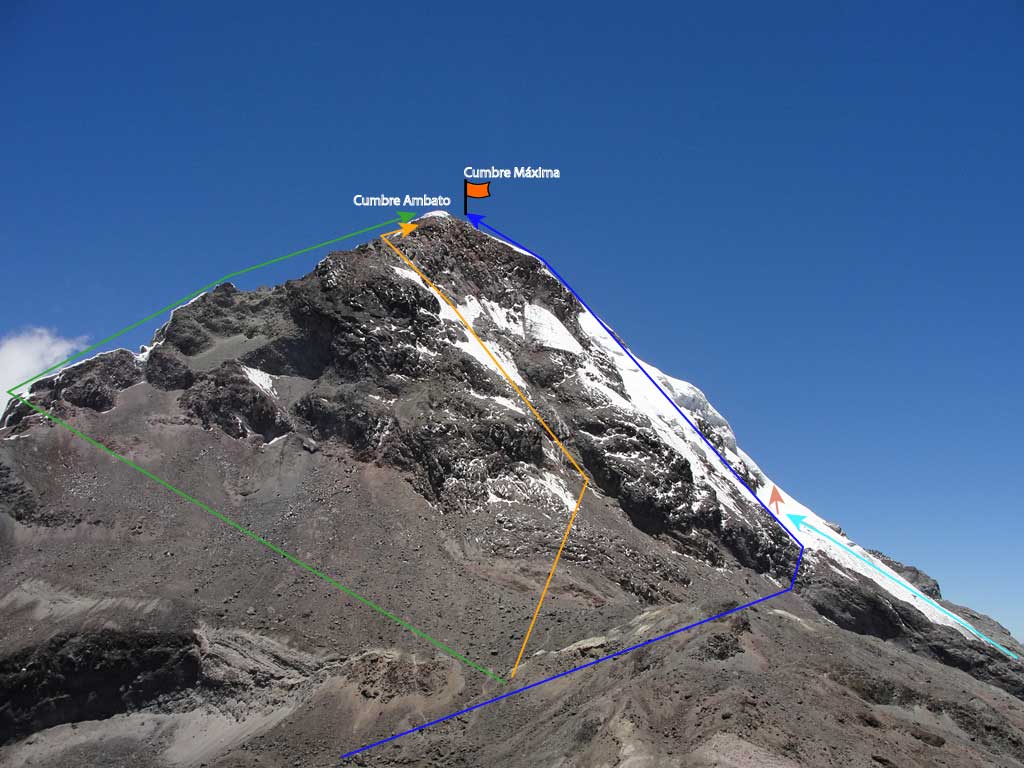
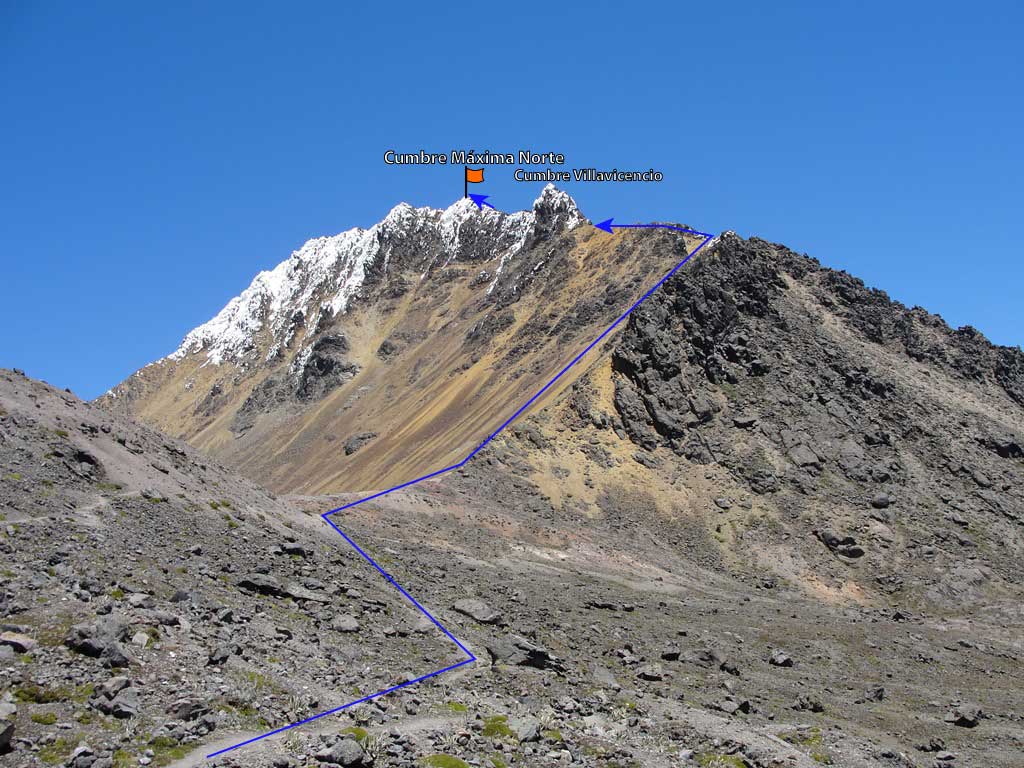
- The trail to North Illiniza runs along the edge of sand and rocks northwest of the refuge, it usually has little or no snow. It is mostly a hike with some light climbs without difficulty. Already arriving at the first peak (Villavicencio) the rock must be circumnavigated on the right side, a sector known as “passage of death”, since there have been fatal accidents there. When the rock is peeled, a de-escalation and short III grade circumvallation on good rock is needed. When there is ice or snow on the rocks it is advisable not to continue without using crampons. There are good rocks to set up security stations.
- Follow the circumvallation maintaining more or less the same elevation until facing the last rocky edge and a rocky channel that continues directly upwards; it is recommended to place a fixed rope for inexperienced climbers. From there to the summit there are about ten additional minutes without difficulties.
- The North Illiniza summit is narrow and can be dangerous when the wind blows strongly or when there are thunderstorms.
- The landscape views from this summit are really of the highest level.
- The descent can be done by a sandy slope that continues down the rock channel, it is convenient to continue along this ridge for another hundred meters, and then try to exit to the sand slope on the right, where you may clearly see the footprint that will allow you to reach the parking lot much faster.
- The ascent to South Illiniza requires technical preparation and complete equipment for ice and snow climbing.
- It is customary to leave the refuge between 3 and 4am to get to the summit early and prevent the snow from loosening.
- Take from the refuge the south-western direction, following a path that zigzags until reaching the “great plateau”, until recently there was a glacier, now it is occupied by a moraine and small snowfields. Continue bypassing the plateau in Western direction until you come to a regular quality rock wall. This IV and V grade climbing will take you into the glacier tongue.
- The glacier average slope is around 50 degrees, reaching up to 70 degrees. In dry seasons it can be covered with a layer of hard ice which adds an additional degree of difficulty.
- It is recommended to carry some ice screws and two snow piles per roped.
- There are some cracks to overcome on the way, their difficulty varies each time and that is why it is important to be prepared for everything. The route has been changing, depending on the appearance or difficulty of these cracks. Already in the upper third you will usually find a larger crevace, it might require a fairly technical climbing level. This crack might require taking to the left and in that case go up to the window between the Ambato and Highest summits, or take the right and try to negotiate the pass directly to the top peak.
- The South Illiniza has lost most of its glaciers and this process seems irreversible. This rapid loss of glacier causes the route to change frequently and new completely unforeseen obstacles appear. Even so, it is still a very beautiful mountain and a classic of the Ecuadorian mountaineering, scenary where many of us have had the opportunity to refine our ice climbing technique.
- The climbing of the South Illiniza will always be a reverberation of adrenaline.
- The descent is usually done by de-escalating the same route; although for safety it may be important one or two rappels.
- Other routes have been opened to the South Illiniza on all its flanks. These are rarely visited and high difficulty routes.
- The Celzo Zuquillo route is now a quite popular variant and reaches the Ambato summit. This route requires climbs from III to V degree on rock of regular quality and sometimes with some verglás (ice on the rocks).
