Sincholagua Map
(Click on the GPS points to see the photos; use two fingers to move the map)
Routes
routes
| Route | Difficulty | Time |
|---|---|---|
| Normal Route | A little difficult (PD) | 9 – 10h |
- Recommendations
Recommendations
- One day is usually used to ascend to the summit of this mountain.
- Following the death of three climbers in Illiniza Sur, given in October 2012, the regulations were drastically hardened to ascend mountains greater than 5000 meters, especially those covered with glaciers. This new regulation prevents any mountaineer from ascending to these summits unless it is attended by a guide certified by the ASEGUIM (Association of Mountain Guides of Ecuador).
- The guards of the Cotopaxi National Park are especially "sensitive" to this "regulations" and sometimes apply it to Sincholagua; each guard applies it to his own taste and depending on his mood of that day; The truth is that mountain lovers will always have to face the headache of dealing with these guards.
- The entrance time to the Cotopaxi National Park is from 8am to 3pm for any of the two accesses, every day of the year. The output is maximum at 5pm.
- The Sincholagua is a demanding mountain, to climb to its summit you must estimate a time not less than 10 hours; as long as you are in a reasonable physical state.
- If you are going to try the Sincholagua summit, you must enter the park at 8am o clock.
- Vehicles are parked next to the old Pita River water station (see map). This station is approximately 10 minutes by car from the North Control.
- Being a walk that lasts ten hours, you can estimate that you will be back at 6:00 p.m. For this reason it is always recommended to carry headlamps; and always warn in the guardianship that you are going to climb this summit and you will possibly be back at that time.
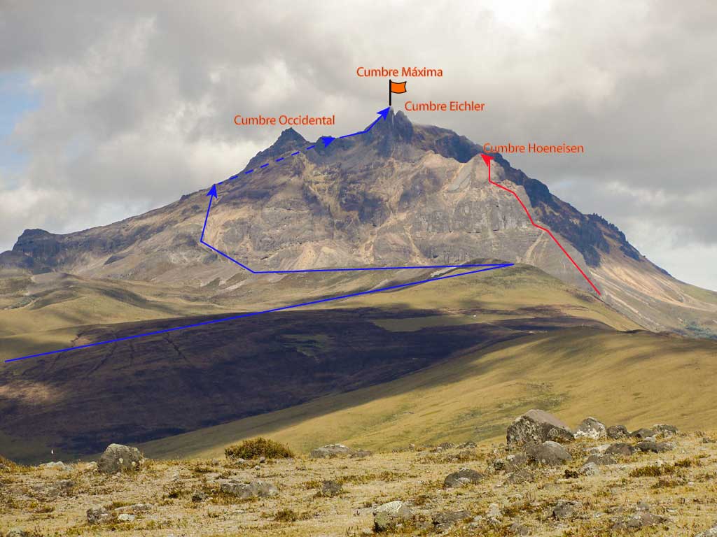
- The route climbs following an old 4x4 car road. This road ends with the paramo at the rocky ridge, at approximately 4200m.
- Subsequently, it continues along this rocky ridge and eventually goes around it on its right side until it reaches the first sandbanks of Sincholagua.
- The normal route goes around the mountain to the north following its western flank. This section is basically a walk in a sandy area without much inclination.
- LThe upper part of the mountain can be covered with ice or snowfields.
- The ascent does not present difficulties until reaching the foot of the highest summit, where there is a section of rock of about 30 meters and an IV degree climbing difficulty. It is recommended to place a fixed rope as an aid for people who have less experience
- The Sincholagua rock is famous for its poor quality. The normal route to the highest summit, due to the number of people who have been climbing it in recent years, has been practically free of loose rocks; However, this problem must be addressed in any other route that is attempted towards any Sincholagua summit.
- The most advisable thing is to descend rappelling these last 30 meters ; much more so if the rock is wet.
- The Sincholagua would seem to have an eternal courtship with the clouds, you will almost always find it covered with a cloud in its highest part.
- Extreme caution is recommended when the weather is rainy and the presence of lightning is glimpsed.
- The descent can be confusing at some places and has led to loss. It is highly advisable to use banners to guide you on the descent.
- The Hoeneisen (or South) summit has rarely been conquered; according to references, it is a very difficult climb in rock of variable quality; The original route followed by the first conquistadors (Miguel Andrade and Hugo Torres) runs along the eastern face through a series of narrow gutters, chimneys and rock walls with extra-thick steps. This route requires a camp in the valley located on the eastern side of this peak.
- Very little is known about the other two Sincholagua summits; especially the Eichler summit which is the twin of the highest peak and second in height.

